
Curzon Park, then and now…..
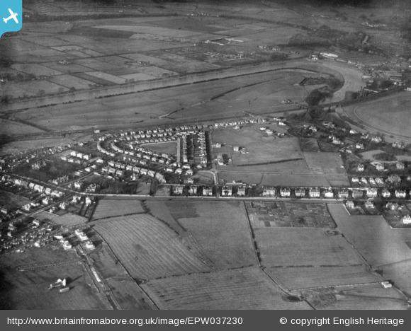
Aerial view of Curzon Park in 1931. For more views of the area visit http://www.britainfromabove.org.uk
Hough Green Local History Group recently produced their excellent book ‘From Bricks to Villas’ on the history of Hough Green. You may also know the ‘Chester Through Time’ book which shows an old picture and then a modern one, taken from the same spot to highlight what has changed.We thought we could try to do something like that on our web pages – but just for Curzon Park! Do you have any old photographs of your house or area from a few years ago? If you have please email Adrian or Dave: photos@cpraonline.org.
We will collect the picture, scan it, and return it to you undamaged. We will then take a photo to match the location, and put everything side by side on our CPRA web pages.We hope you can help.
**************************************************************************
- A Short History of Curzon Park – Clive Howard
- ‘Come with me to Curzon Park’ – Margaret Churton
- My Early Childhood in Curzon Park – Joyce Cook
- The Sepentine and The Paddock
CPRA thank Clive Howard, Margaret Churton and Joyce Cook for allowing us to include their fascinating histories of Curzon Park on our website.
**************************************************************************
Other Historical Documents relating to Curzon Park:
**************************************************************************
Aerial views of Curzon Park and Saltney – 1931
Select the following links:
CP1931 for an aerial view of the early development of Curzon Park in 1931.
Lache Lane and Environs, 1931 Only farmhouses on Lache Lane, and housing on one side of Hough Green, with west end of Curzon Park fully built. The Green, Northway, Greenway, Park Road West, lower Earlsway, one side of Selkirk Road and Hough Green are clearly visible and are well established. Otherwise, much of Curzon Park remains farmland and ripe for pre- and post-war housing development! Go to the History menu to read all about the early days of Curzon Park. It would be fascinating to compare an aerial view of Curzon Park today with the 1931 view. Can anyone help?
1926 aerial views:
Crichton’s Shipyard, Saltney – located on the River Dee, just beyond the railway bridge over River Lane.
River Lane just that, and the Golf Course.
Saltney High Street and River Lane crossroads (no traffic lights yet), leading to Critchon’s Shipyard. The railway sidings adjacent to the crossroads can be clearly identified. Now replaced by the Business Units on Boundary Lane, known as………The Sidings!
Just open fields and farms. Chester FC and Retail Parks nowhere to be seen.
Historical overhead pictures of the local area, plus interesting comments about them, can be viewed on: http://www.britainfromabove.org.uk/. Just enter your area of interest in the search box eg Saltney, Lache, Hough Green. To zoom and download the pictures, you will have to register your email address.
**************************************************************************
The Hough Green Local History Group have published a book ‘From Bricks to Villas’ on the history of Hough Green over the last 600 years, from its brick making days to the present. Residents who may be interested in purchasing the book can select press release for more details.
The book, priced at £14.95, is available from the Hough Green Local History Group by mailing local.history@raycar.plus.com
**************************************************************************
Other local history
The Chester Chronicle have published a page of old Chester pubs
The Architect have a page about St Martins Villa – click on HISTORY
